From Rule's Standard History of Knoxville, Tennessee, with Full Outline of the Natural Advantages, Early Settlement, Territorial Government, Indian Troubles and General and Particular History of the City Down to the Present Time. Chicago: The Lewis Publishing Company, 1900.
The completion of the Kingston pike in 1894 from Knoxville to Campbell's station, a distance of fifteen miles, was an event of great importance both to Knox county and Knoxville, increasing as it did the trade of the town and the ease with which farmers and others could drive over the road. The time required to drive this distance on the old dirt road was about five hours, while after the completion of the pike two and a half hours was quite sufficient.Charles McClung, the Pioneer Road Builder — Stage-Coach Lines — Progress in Turnpike Roads — The Tennessee River and Tributaries — First Steamboat at Knoxville — Railroad Building — The East Tennessee and Georgia and the East Tennessee and Virginia Roads — The Great Southern System — Roads to Atlanta and Cumberland Gap — Bridges — Street Railways.
|
|
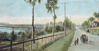
| Kingston Pike, circa 1910 |
In 1792 Charles McClung, from whom the numerous and honorable McClung family of Knoxville have descended, came from the vicinity of Philadelphia, Pa., and by the first county court held in Knox county was engaged to locate a public highway from Knoxville west to Campbell's station, and thence to the western boundary of Knox county. There was already a bridle path following pretty closely after an Indian trail to Sinking creek, but here a divergence was necessary. At Campbell's station there was a block house and a considerable settlement. In this connection it is important to note that the Indian trails usually followed the ridges, in order that the Indians following these trails might overlook the valleys, in which settlements were for the most part made, and thus discover the existence of settlements from the rising columns of blue smoke ascending from the cabins in the nooks and crannies of the forests. Just east of Sinking creek this trail turned abruptly to the south, extending in that direction for a short distance, then ran along the slope of Chestnut or McAnally's ridge to an Indian town on the Tennessee river near the present site of Concord, and thence to the Cherokee country beyond the Little Tennessee.
The road as originally laid out by Mr. McClung was about thirty feet wide, cut the greater portion of the way through the primeval forest. At that time the county of Knox contained only about 2,000 inhabitants, and this undertaking was one of no small magnitude. Many years later the road was widened to fifty feet, every land owner along the way freely giving of his land to the extent made necessary by this widening of the road. Before the beginning of the present century the road reached Kingston, and later on it formed a part of the great national highway from Washington to Knoxville, to Nashville, to Montgomery and to New Orleans.
Along this national highway the means and methods of travel were wonderfully different from those at present in vogue. On that part of it between Knoxville and Washington, in 1842, there was a line of stages, called "The Great Western Line," and in the advertisement of the company owning and operating this line they said that the trip between the two cities could be made in six days and six hours. The line ran by the way of Warm Springs, Asheville, Rutherfordton, Salisbury and Greensboro to Raleigh, a distance of 385 Miles, the fare between Knoxville and Raleigh being $25. From Raleigh to Washington the traveler went by rail and steamboat, a distance of 288 miles, making the entire distance 673 miles. From Raleigh to Washington the fare was $19, making the fare between Knoxville and Washington $44, the time, "only six days and six hours," being considered remarkably short, as it in reality was, considering the means of travel. The schedule time now is 19 hours, 50 minutes.
The Kingston Turnpike company was chartered by a special act of the legislature of the state passed May 24, 1866, the company being organized September 17, succeeding a board of commissioners appointed for the purpose by the legislature. This preliminary board consisted of the following gentlemen: Perez Dickinson, Joseph A. Cooper, O. P. Temple, Charles M. McGhee, and Robert H. Armstrong. A board of directors was elected consisting of Robert H. Armstrong, O. P. Temple, Charles M. McGhee, Joseph A. Cooper, and George W. Mabry, the officers of the company being O. P. Temple, president, and Robert H. Armstrong, secretary and treasurer. As fast as the company could raise funds it macadamized the road, and soon after five miles had been thus improved, a toll gate was established and tolls collected which were applied to the further macadamizing and improving of the road. The county of Knox was a stockholder in the company, and in 1892 became by purchase of the remainder of the stock the sole owner of the pike. Soon afterward an order was issued to extend the road to the county line, the work to be done by the convicts of the county, and the pike was completed to Campbell's station by November 1, 1893, at which time the purchase above mentioned was effected, the county paying the other stockholders $20,000 for their stock.
In 1876 Knox county established a workhouse for the punishment of criminals with the view of devoting their labor to the building of roads. Work was begun as soon as practicable, and by January 1, 1892, there had been constructed seventy-seven miles of turnpike roads. During 1892 there were constructed three miles of the Third Creek pike, reaching Beaver ridge, nine miles from Knoxville, and also a mile on a branch of this pike, into Hind's valley. There were also constructed five miles on the Kingston pike, making eight miles in all this year, or nine miles considering the short branch into Hind's valley. The board of pike commissioners built during the year seven and a third miles of pike road, or an equivalent of this length, as follows: On the Sevierville pike, one and one-fourth miles; Pickens Gap pike, one and three-fourth miles; Neubert Springs pike, three-eighths of a mile; Maryville pike, one and one-third miles; Rutledge pike, one-half a mile; Brabson Ferry pike, one and three-fourths miles, and in the Twentieth district, one-eighth of a mile. At the end of 1892 there were about ninety-five miles of turnpike road in the county, which cost in the neighborhood of $300,000.
In addition to the above there was the Tazewell pike, seven miles long, which was owned by a private corporation, and together with this seven miles of Tazewell pike there were about 102 miles of good turnpike road in the county, all of course running into Knoxville and increasing its trade. At the present time (February 1, 1899), the different turnpike roads leading out from Knoxville are of the following lengths:
Besides the above pikes which radiate from Knoxville in various directions, there are several cross pikes, connecting the main ones, to the extent in the aggregate of about ten miles. Thus the entire length of turnpike roads in Knox county connecting Knoxville with the country, is 173.5 miles, to which adding the ten miles of cross pikes, makes the total length of such roads in the county at the present time, 183.5 miles.
The Tennessee river, taken as a whole, is a wonderful stream. From the junction of the Holston and French Broad, which of late years has been considered its origin, though formerly the name Holston was applied down to the confluence of the Little Tennessee, the distance to its mouth is 650 miles. Including its tributaries it has more than 1,300 miles of water navigable for steamboats, and when only flat boats are taken into consideration it is navigable for more than 2,200 miles; that is, it and its tributaries together.
In 1820 the government appropriated several thousand dollars for the improvement of the Mussel Shoals, and in 1829 it appropriated $4,000,000 for the construction of a canal round the shoals; but as there was no appropriation ever made either by the government of the United States or by the state of Alabama for keeping the canal in repair, it was neglected and was in use only a few years. And while previous to 1897 there had been considerable money spent in improving the river below Chattanooga, very little had been done in this way above that city.
But the amount of business done on the river showed that it was worthy of attention. In 1896 there were sixty-four steamboats on the river, with an aggregate capacity of 80,000 tons. During the year these sixty-four steamboats carried more than 20,000 passengers and 20,000,000 tons of freight. About 3,000,000 tons of this freight were carried between Knoxville and Chattanooga. The French Broad is used much more than other of the tributaries of the Tennessee, for the reason that there is but little railroad built up its valley. In 1896 the French Broad carried about forty times as much freight in value as had been expended on the Tennessee in its improvement, including all the appropriations made since the first one mentioned above, in 1820.
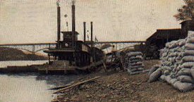 |
| Riverboat unloading cargo in Knoxville, circa 1910 |
The citizens of Knoxville are very much interested in the improvement of this splendid stream. They think that with an expenditure of about $600,000 the channel of the Tennessee could be made three feet deep at low water all the way to Chattanooga, and if this depth were secured the river would become a competing line between these two points. The Tennessee river improvement committee of the Knoxville Chamber of Commerce has this matter constantly under consideration, and is doing all in its power to secure an adequate appropriation.
The first steamboat to arrive at Knoxville was the Atlas, a small boat which had made its way through "The Suck" in the Tennessee river to Knoxville in 1826, and which greatly astonished the citizens by its movements. The commander of the Atlas was Captain Connor, who was greeted on his arrival by a dinner and by speeches and was honorably toasted. The arrival of this little boat suggested to the citizens of Knoxville the possibilities of the navigation of the Holston and Tennessee rivers by means of steamboats, and almost immediately a company was organized with the view of purchasing a steamboat for the purpose. The steamboat thus purchased was designed to run between Knoxville and "The Suck," the place where the Tennessee cuts through the Cumberland mountain range. One of the members of this company was sent to Cincinnati to make the purchase, and the steamboat thus purchased was brought to Knoxville and named in honor of the town in which lived the members of the company that thus established the navigation of the Tennessee, for the attempt of the Atlas to so navigate the river was only a suggestion as to what might be done. When this new steamboat, the Knoxville, arrived at the wharf there was great excitement in the town, for it was looked upon as an event opening up a new era in its history.
In 1848 William Williams and James Williams, the latter of whom was minister plenipotentiary under President Buchanan to Constantinople, began the wholesale grocery business in Knoxville under the firm name of Williams & Co. Their warehouse was located on the river at the foot of Gay street. They purchased the steamer Cassandra, and a short time afterward built the Kate Fleming and the Chattanooga. The former was in the trade between Louisville, Ky., and Cairo, Ill., in the fall of 1850, until such time as high water in the Tennessee river would permit of her passage over the Mussel shoals; but she was burned to the water's edge just below Louisville in October of that year. The Chattanooga, however, succeeded in getting over the shoals, and at once went into the trade between Knoxville and Decatur, Ala. This boat was 145 feet long and 23 feet beam, and of 160 tons burden. Her full length cabin was finely fitted up and furnished for carrying passengers, her captain being McMahon and clerk, James E. Williams. This boat was a success in every way, running from and to Knoxville nine months in the year. Then followed in a short time the Mollie Garth and the Lady Augusta. The river traffic was considerable until the completion to Knoxville in 1855 of the East Tennessee and Georgia railroad, and then it was that Williams & Co. closed out their business and the passenger and freight business, until that time enjoyed by the river, was gradually transferred to the railroad, that on the river gradually sinking into insignificance.
In 1895 the following boats were on the Tennessee river, and were more or less intimately connected with Knoxville: The steamer Telephone, owned by the Union Boat, Store and Warehouse company; the Flora Swan, owned by the Knoxville, Sevier and Jefferson Steamboat company; the Lucile Borden and the Onega, owned by the Three Rivers Packet and Transportation company; the Oliver King, owned by Oliver King; the Bill Tate, owned by the Holston River Packet and Transportation company, and the City of Knoxville, owned by C. R. Love & Co. The Onega was built in 1891, is 106 feet long, and has a net tonnage of 74-77 tons. The City of Knoxville is 130 feet long, and has a tonnage of about 100 tons. The Dixie is a new boat, built in Knoxville, and is owned by Oliver King of that city. The Three Rivers Packet company has a shipyard, located on the south of the river about 200 yards above the bridge, at which they repair such boats as may need to be repaired. So far they have built no new boats. All of the above-named boats are on the river at the present time.
All HTML code on this page was created by and copyrighted ©1999-2002 to Billie R. McNamara. All rights reserved. Please direct all questions and comments to Ms. McNamara. Background graphic image was borrowed from Fred Smoot. Used by permission.