|
|
|
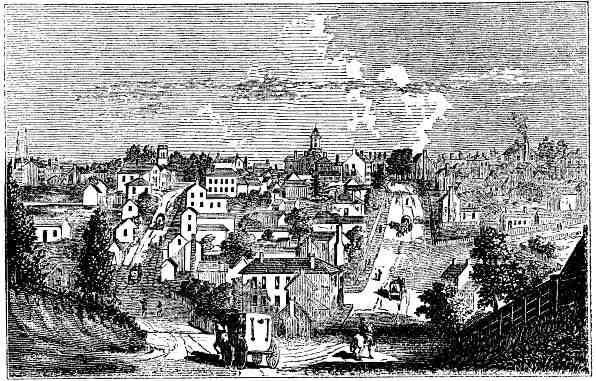
Knoxville is situated on the north bank of Holston River, 4 miles below the junction of the French Broad River, 185 miles east from Nashville, and 214 from Lexington, Ky. It is quite a flourishing place, a central point of intersection of all the treat railroads of the country, east, west, north and south. Fine marble quarries and iron ore abound in this section, and beds of bituminous coal on the line of the railroads. The river is navigable downward for steamboats at all seasons, and in the spring some 30 or 40 miles above to Dandridge.
Few places possess such a variety of scenery as can be found within the limits of Knoxville, exhibiting on the banks of the Holston the wild and picturesque beauty of nature, the hills and valleys of the cultivated country, the manufacturing village, and the features of the city. Knoxville contains six churches, the county buildings, of which the jail, a castellated building, makes a striking appearance, the University buildings, and the State Deaf and Dumb Asylum. Population about 9,000. East Tennessee College, or University, is located on a commanding eminence, upward of 200 feet high, and about half a mile from the court house. This institution was founded in 1792.
Knoxville was first laid out by Gen. James White, the first patentee. East Knoxville was laid out by Moses White, his son, and at first was called Mechanicsburg. The west end of the town was laid out by Col. John Williams, and was for some time called Williamsburg. Gov. Blount's residence was on Barbara Hill, where the University buildings now stand. The hill received its name from Barbara, the daughter of the governor, who was born on its summit. The Presbyterian church was the first house of worship erected in the place, Rev. Wm. Carrick the first minister. Dr. Strong, the first physician, was previously a surgeon on board the U. S. frigate Constitution. John Crosier [Crozier], it is believed, was the first post-master.
The Hon. Hugh L. White, U. S. senator, who died in 1840, was the son of Gen. White. Robert Huston was the first sheriff, and Robert Armstrong the first surveyor. John Hood was the first, or one of the first printers in Knoxville; he printed the Knoxville Gazette.
All HTML code on this page was created by and copyrighted 1999-2002 to Billie R. McNamara. All rights reserved. Please direct all questions and comments to Ms. McNamara. Background graphic image was borrowed from Fred Smoot. Used by permission.